The headwaters of the Little Missouri River, historically called Wakpa Chan Shoka, are in northeastern Wyoming. The river flows from south to north through parts of Wyoming, Montana, South Dakota, and the rugged badlands and rolling prairie of western North Dakota. --USGSWyoFile's Dustin Bleizeffer:
The greater sage grouse — the West’s best metric for the health of the western prairie ecosystem — is teetering on the edge of an Endangered Species Act listing. Yet just one nasty wildfire in the wrong place, or one more major outbreak of the West Nile Virus, and the greater sage grouse may become functionally extinct in the Powder River Basin, erasing a critical lifeline for genetic diversification between other sage grouse populations in Wyoming and Montana, according to wildlife biologists.Construction has begun on the Bakken Pipeline originating near Sidney, Montana. If completed, it would transport raw natural gas liquids (NGLs) south through easternmost Montana and Wyoming into northern Colorado, where it would connect to the existing Overland Pass Pipeline.
KW sez:
[W]ork is scheduled to start on the Crook County section of the pipeline — the last to begin — within the next 10 days. But the issue is important enough to keep pursuing, said Charles Nicholas of rural Spearfish, a member of the Lawrence County Conservation District Board of Supervisors. Nicholas and other critics of the pipeline route worry that the unstable geology — including gypsum-karst formations that can produce sinkholes more than 100 feet across — of the Wyoming valley between Beulah and Sundance makes it unsuitable for pipeline construction and energy transport. At the request of Crook County Commission members, ONEOK will host an open house about the pipeline from 11 a.m. to 1 p.m. Friday at the courthouse in Sundance.
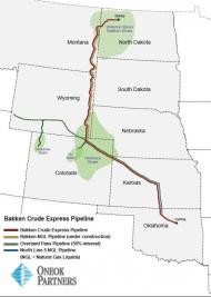
It would intersect with the Belle Fourche River just west of Belle, the Redwater River between Aladdin and Beulah, the Cheyenne River near Mule Creek Junction west of Edgemont, and the North Platte near Fort Laramie terminating at the divide with the South Platte River not far from the tiny Colorado hamlet of Last Chance that was reduced to a pile of rubble by a recent wildfire.
Two days ago a red flag warning was issued for the entire area affected by this proposed pipeline.
5 comments:
The Cato fire in northern Johnson County burned about 27k acres, much of which was prime sage-grouse habitat, including one of the most productive leks in NE WY.
It's probably no longer a question of if, but when, the WY energy colony will wipe out the sage-grouse and reduce mule deer below huntable levels.
Red flag warnings and critical fire Wx persist for the proposed pipeline route today.
The Sundance Times story.
Crook County caves to Oneok: Sundance Times.
Another pipeline proposed for Powder River Basin: Gillette Record.
Post a Comment